Very few people both live and work in the Cove. The vast majority of people are commuting back and forth towards central and western Madison County, utilizing one of the few routes that crosses the mountains separating the Cove from the rest of Huntsville and Madison.
This webpage provides information on travel options and commute strategies, with particular focus on easing commutes in 2019 while a number of local infrastructure projects and plans are simultaneously underway.
Cecil Ashburn Information
The Cecil Ashburn corridor project began on January 7th, 2019. Phase 1 consists of a full closure of Cecil Ashburn Drive between Avalon Drive and Old Big Cove Road for 10-14 months. Construction will also take place on Sutton Rd, which will remain open. At the end of Phase 1 (projected as October 2018), two lanes of traffic on the entire corridor will be open 24/7, and construction will continue for another 4-8 months to open the remaining two lanes on the mountain and finish signal and corridor work on Sutton. Additional details can be found at the following links:
- GrowCove – Detailed Project Information from bid documents
- City of Huntsville – Roadwork Updates
- City of Huntsville – Commuter 101
Construction Impact Mitigation
With limited ways to get in and out of the Cove, the closure of any major route has significant impacts.
GrowCove has been working with the City of Huntsville to lessen disruption in the Cove and, while we were not entirely successful in achieving all of our objectives prior to roadwork commencing, there are a number of measures that have now been put in place to mitigate impacts.
- New signal on US 72 at Rock Cut Road
- Traffic Light Optimization on Governors
- Emergency Vehicle Signal Preemption
- Emergency Service Cooperative Agreements
- Strict speed limit enforcement to reduce speeding-related crashes
- Informational signs in region relating to closure and detours
- Promotion of ridesharing
- Creation of temporary Park & Ride locations
- New local business programs and social events to keep residents in the Cove for discretionary activities (follow GrowCove and CoveMonkey on social media for more info!)
Even with these measures, if we do not collectively change our travel habits, we run the risk of overloading certain portions of 431 / Governor’s Drive and creating safety hazards during peak travel times (6:45-8:15am and 4:30-6:00pm), due to the relative inability to easily divert from this route.
Congestion Reduction Strategies
Traffic congestion is created not so much by the number of people trying to get between destinations, but by the number of vehicles traveling on the same route at the same time.
Following is a list of strategies that people can undertake to reduce the number of cars on the road at the same time and use our remaining infrastructure more efficiently.
*Reduce, Reroute, Reschedule or Ride Together* for a better commute in 2019.
- Reduce. Eliminate trips over the mountain completely by telecommuting or changing discretionary activity locations to the Cove, if possible.
- Reroute. Choose alternative routes. Both US-72/I-565 and Hobbs Island Road are recommended alternatives to 431. Unfortunately, due to the physical conditions of Green Mountain Road and Dug Hill Road (including steep grades, sharp turns, poor visibility, missing shoulders, and pavement issues) these routes are not recommended for frequent use. Trailer trucks, in particular, should not use Green Mountain Road or Dug Hill Road at all for through trips.
- Reschedule. Shift automobile trips to off-peak times, via flex schedules or rescheduling activities as needed. For those on a 4-day/week work schedule, consider scheduling off-days between Monday-Thursday, rather than Friday. Try to travel in congested segments (Governors between I-565 to Monte Sano Blvd, and 565 over Chapman Mountain between Oakwood and Moore’s Mill) as little as feasible between 6:45am-8:15am or between 4:30pm-6:00pm.
- Ride Together. If you must use Governor’s Drive during typical weekday rush hour, eliminate a single point of congestion by sharing a ride with a friend, colleague, or neighbor. Carpool or Vanpool to work, school, or other activities. Free and easy-to-use resources are below.
Based on current traffic counts and patterns, choosing to implement any of these strategies, in any combination, twice a week, will likely alleviate most issues on 431 / Governor’s Drive in particular.
We all have the power to prevent unsafe congestion and have better travel experiences.
Alternative Routes and Travel Time
In general, for people that live towards the eastern end of Little Cove Road (i.e. McMullen Cove or exiting Hampton Cove from Quarter Lane and beyond), the recommended route in/out of the Cove is US-72 via Rock Cut Road. For people that live near Taylor Road, the recommended routes in/out of the Cove are Hobbs Island Road and Governor’s Drive.
Click the images below for a comparison of alternate routes and duration of trip times on weekdays (Monday-Thursday). They are shown roughly in the order that they are recommended. The second page of each image attachment includes updated estimated travel time ranges to account for extra congestion. Governor’s Drive is expected to be most affected by extra traffic.
In off-peak hours, vehicle travel time is expected to be towards the left end of the “green zone”, while during congested periods, it may approach the “red zone”. The shorter the bar, the less variation is expected in overall trip duration, and more predictable it will be.
Due to the Cecil Ashburn closure, approximately 10-15K vehicle trips per day are expected to redistribute over various alternate routes in and around the Cove area.
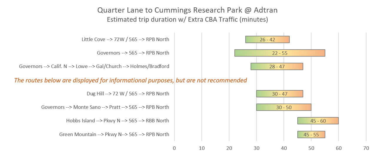
Example AM Commute – Little Cove Road (Quarter Lane) to CRP. Click image for more destinations.
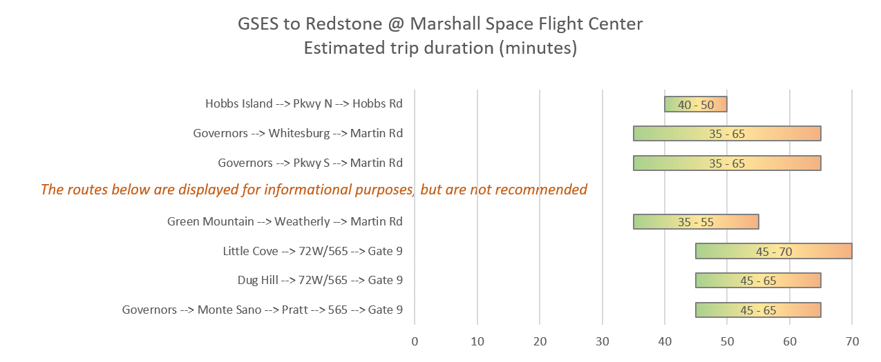
Example AM Commute – Taylor Road (GSES) to NASA. Click image for more destinations.
Gurley and Scottsboro area residents and workers should use US-72. Guntersville area residents and workers should cross the lake on AL-69 and access Huntsville via US-231 through Lacey Spring.
One of our GrowCove members made a number of route maps to the Arsenal. Check them out here.
Ridesharing Resources
- Getting around during the day without your own car
- RideGuru website – Lyft, Uber, and local taxi companies operate in Huntsville and, as of January 1st 2019, on Redstone Arsenal if drivers have access badges. Use the mobile-optimized RideGuru website or ios App to get instant and accurate fare estimates for all services at the same time, and hail a ride on the spot.
- Redstone Arsenal Bicycle Policy – keep a bike on base, just don’t use it on Martin or Rideout Roads between 6am-5pm. Other routes are open to cyclists.
- Downtown commuters have many options, including walking to nearby retail, Pace (formerly Zagster) bikeshare, and shuttle buses (new routes and extended hours implemented as of July 1, 2019, as per the recommendations of a recent transit study).
- Handi-Ride Paratransit services the incorporated areas of the Cove on Mondays, Wednesday, and Fridays, as of July 1st, 2019. Advance reservations must be made. More information can be found on the City Transit webpage.
- CommuteSmart Huntsville – free regional ridematching service offered by the Regional Planning Organization to facilitate the creation of carpools or vanpools. Signing up for this service does not require you to use it, but will help you to easily find neighbors or colleagues with similar schedules, to share rides with as convenient for all parties.
- Enterprise Vanpool program – Reduce stress and wear & tear on your own vehicle by using a rented one to transport 4+ people. Federal employees are eligible for a pre-tax benefit of up to $265/mo to cover costs. It is not necessary to use this method every day to receive the vanpool benefit. Many programmatic guidelines indicate that just commuting the majority of the time via vanpool (i.e. 11+ of 20 working days per month) is sufficient.
- Map of Park N Ride Lots– several establishments in the Cove have formal Park and Ride areas, which carpoolers or vanpoolers can use as convenient and safe meeting spots. Outlying areas and various other establishments may have informal locations that can be used by commuters as necessary.
- DIY Carpool – copy/download and modify as needed. (Requires a Google Account.)
- Generic Rideshare Survey in Google Forms –> customize and share this survey with coworkers, classmates, or others you would consider carpooling with. You may want to go through your Human Resources department, or other admins, as applicable. Under the “Responses” tab, enable “view responses in Google Sheets”, which is used for the next step
- Map survey results using Google My Maps –> Create a new private map and “Import data” from the survey spreadsheet above so people can easily arrange carpool groups with neighbors. Share this map with the participants via direct link or the email addresses provided.
- Generic Carpool Coordination spreadsheet –> All participants should download the Google Drive app to their phones to open the spreadsheet and easily see who is the driver or passenger(s) each day
- School Carpool Apps – if the DIY version isn’t enough, here are two free recommended apps to assist parents in transporting kids to/from school and activities. Both of these are also deployable at the school or district level.
Media Resources
Check regular and social media for incidents that may affect your commute:
- General Traffic Conditions and incidents – Waze App or Google Maps App (iOS or Android)
- COH Incidents and Emergency Notifications (HPD, HFR, HMC EMA) – CivicReady
- COH Police-reported crashes and lane closures – Nixle (
SMS messages andemail). - Redstone Arsenal Conditions – Redstone Explorer App (iOS or Android)
- General conditions on Twitter – Madison County Sheriff Dispatch, Madison County EMA, Huntsville Police
- Incidents on State Routes – ALGO Traffic (web)
- City of Huntsville Roadwork Updates (web)
- Local News – WAFF, WHNT, WAAY
All of these local agencies also have Facebook pages, which may or may not be updated at the same frequency as the sources above and are subjected to facebook algorithms for visibility.
If you would like to utilize Facebook for traffic information, the following webpages have the most frequent postings. Cove Monkey, Owens Cross Roads Police, Madison County Commission District 3, Madison County Sherriff’s Office
Other Resources
- How much does your commute cost?
- Online Shopping and shipping/delivery flexibility to mitigate truck congestion
Have any comments or changes you would suggest for this page? Please contact [email protected].